Russian Shahed drones detected transiting from Kursk toward Sumy Oblast overnight
What happened
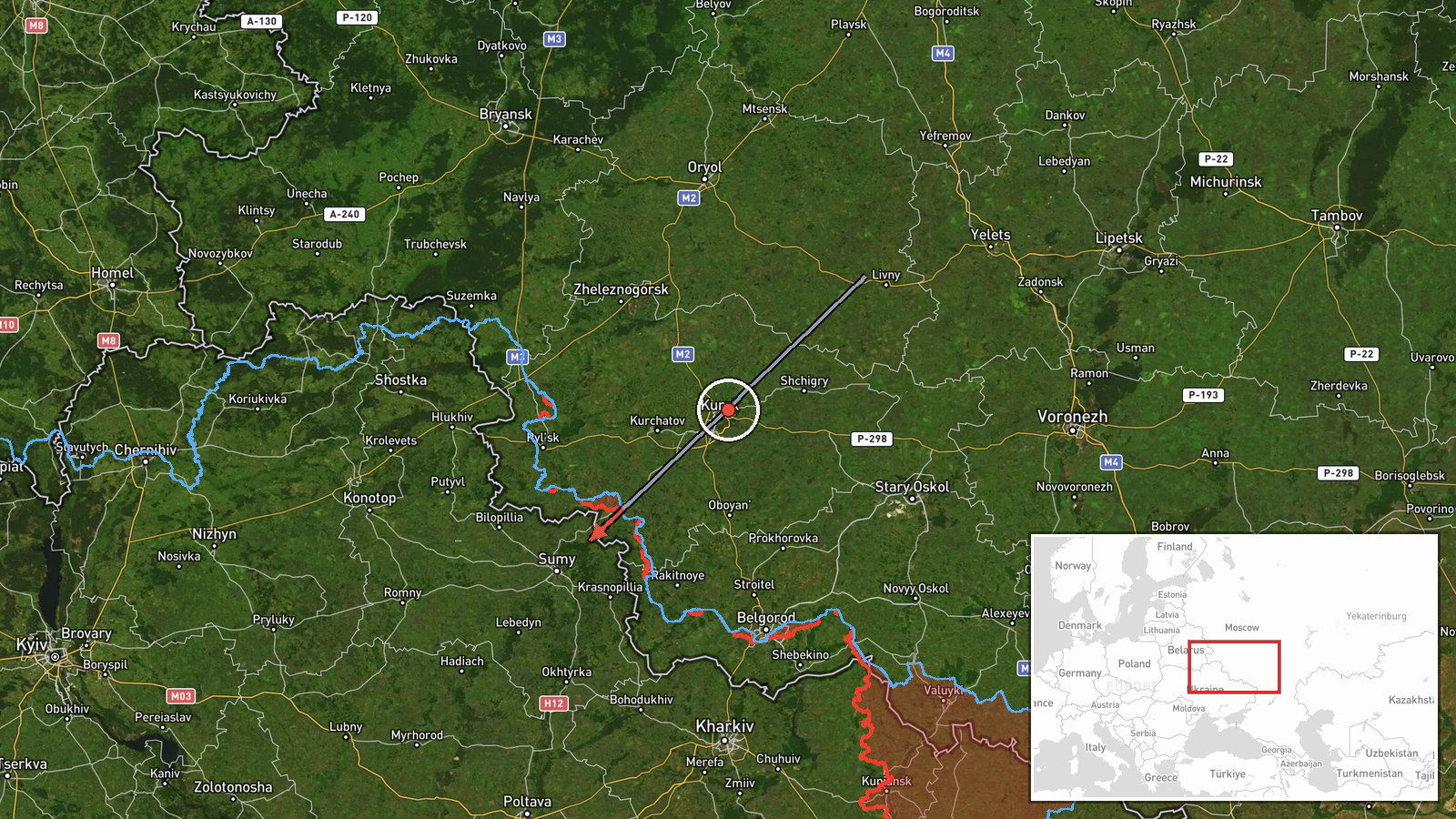
Ukrainian air-raid monitoring reported Russian jet-powered Shahed drones departing Kursk Oblast and transiting toward Sumy Oblast on the night of September 7, 2026, at approximately 21:29 UTC. The detection was part of continued overnight drone operations. The original monitoring alert used the abbreviated Ukrainian phrasing 'Vykhid Kursk, vektor Sumshchyna' (Exit Kursk, vector Sumy region). No specific targets or impact were reported in the alert.
Context and assessment
This transit detection occurred during an intensive overnight drone campaign. Ukrainian air defenses had engaged 92 Shahed and Geran drones earlier that evening, successfully intercepting and suppressing 71 of them across eastern Ukraine and multiple frontline sectors. Concurrent alerts also warned of similar drone transits toward Kyiv and Kharkiv oblasts, as well as ballistic missile threats from the same Kursk staging area. The pattern suggests a coordinated multi-vector attack designed to overwhelm air defenses across multiple regions simultaneously. Sumy Oblast, located in northeastern Ukraine along the Russian border, has been subject to sustained drone and missile strikes targeting both military and civilian infrastructure.
Sources and confidence
Single source via Telegram channel @war_monitor, a Ukrainian air-raid alert aggregator. No cross-confirmation from other independent sources provided. Confidence score of 6.0 reflects the source's established track record in real-time monitoring but the inherent limitations of a single reporting channel. Confirmation would require Ukrainian official military or air defense statements, or subsequent reports of drone interceptions in the target region.
Location
Transit route spanning Kursk Oblast (Russia) to Sumy Oblast (Ukraine), determined at regional precision level. Sumy lies in northeastern Ukraine along the Russian border, approximately 40 kilometers from Kursk. The coordinate point (50.90°N, 34.80°E) places the observation near the Kursk-Sumy border region. No specific facility or settlement was identified as the origin or intended target.
Related events nearby
- Ukrainian air-raid monitoring: 2 groups of Russian cruise missiles detected transiting Ukrainian airspace, pas2026-09-08 01:03 UTC · Cruise Missile · En route: Shostka → Konotop/Pryluki, Sumy Oblast,
- Ukrainian air-raid monitoring reports threat of Russian jet-powered (reaktivnyi) Shahed drones transiting towa2026-09-07 21:03 UTC · Drone Transit · Kyiv Oblast and Kharkiv Oblast, Ukraine
- Ukrainian air-raid monitoring reports Russian jet-powered Shahed-136 drones (reaktivy) detected in transit fro2026-09-08 00:31 UTC · Drone Transit · Kursk Oblast, Russia (launch/transit origin)
- Ukrainian air-raid monitoring alerts to threat of Russian Iskander or S-400 ballistic missile launches from Ku2026-09-07 21:24 UTC · Ballistic Missile · Kursk Oblast, Russia
- Ukrainian air-raid monitoring detected 4 groups of Russian cruise missiles transiting the Sumy-Chernihiv borde2026-09-08 01:35 UTC · Cruise Missile · Sumy-Chernihiv Border Region, Ukraine
▶ View this event on the live map
Intel Mapper aggregates open-source reports from monitored Telegram and X channels, geolocates them, cross-checks duplicates across sources and assigns a confidence score. Entries are updated as new confirmations arrive. Read how we verify events.